
Murchison Falls: How the World’s Most Powerful Waterfall Was Formed
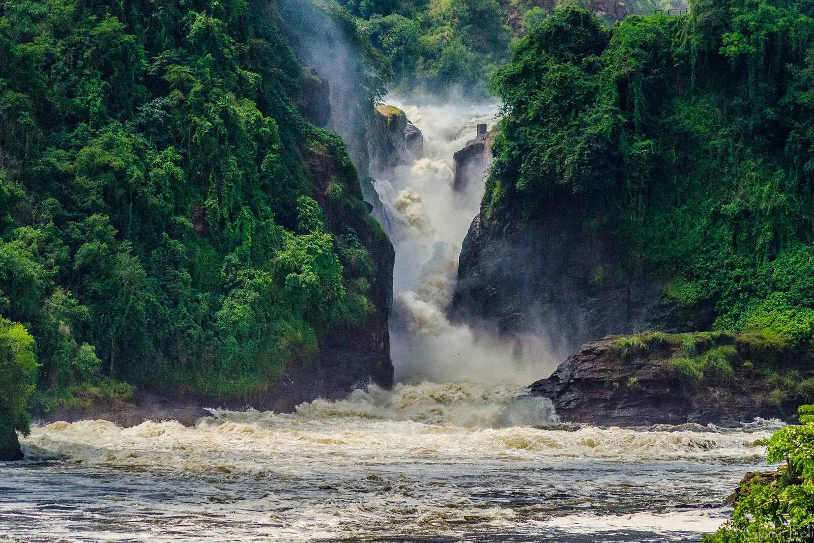
Standing at the viewpoint directly above Murchison Falls, watching the entire Victoria Nile compress into a gap barely seven meters wide before exploding violently through the gorge below, most visitors ask the same question almost instinctively: how did a river this size get squeezed into a channel this narrow. Murchison Falls genuinely earns its reputation as the world’s most powerful waterfall not through sheer height alone, at just 43 meters it is considerably shorter than many famous waterfalls elsewhere, but through the sheer force generated by compressing an enormous volume of water through an extraordinarily narrow gap, a genuinely dramatic geological story spanning millions of years in the making that turns a relatively modest vertical drop into one of the most visually and acoustically overwhelming natural spectacles anywhere in Africa.
The Rift Valley Origins Behind the Falls
Murchison Falls exists because of the same tectonic forces that created the broader Albertine Rift, the western branch of the East African Rift System, where the African continent is slowly, over geological timescales, pulling apart along a series of fault lines. The Nile flows over what geologists describe as a graben border fault, part of the Bunyoro Escarpment, as it descends steadily from the higher elevations of the surrounding plateau down toward the rift valley floor and Lake Albert below it. This fault-controlled terrain, rather than any single volcanic event or sudden geological catastrophe, set the stage for the specific narrow channel the river would eventually carve at Murchison Falls, meaning the falls are ultimately a direct product of the same rifting process responsible for shaping the Albertine Rift’s lakes, escarpments, and mountain ranges across the wider region. This same rift system produced Lake Albert immediately downstream and the dramatic escarpment terrain visible throughout much of Murchison Falls National Park’s landscape, meaning the falls themselves are best understood not as an isolated geological curiosity but as one visible expression of the same continent-scale rifting process shaping this entire corner of East Africa.
How the River Carved Its Narrow Channel
Over countless centuries of steady flow, the Nile’s persistent current gradually eroded a passage through the harder rock formations along this specific stretch of its course, cutting deeper and narrower over time as the softer surrounding material wore away faster than the more resistant rock the river ultimately squeezed through. This slow, patient erosional process produced the genuinely dramatic gorge visible today, steep rock walls rising on either side of a channel so narrow that the entire Victoria Nile, a river carrying roughly 300 cubic meters of water per second, compresses into a gap measuring barely seven to ten meters wide at its tightest point. The resulting pressure and velocity as this genuinely enormous volume of water forces through such a tightly constrained space is precisely what generates the falls’ famous power, a physical consequence of basic fluid dynamics playing out at genuinely dramatic, almost overwhelming scale. The same principle explains why a garden hose fitted with a narrow nozzle sprays water with far more force than the same volume flowing freely from an open pipe, simply scaled up to a river carrying hundreds of cubic meters of water every single second rather than a household trickle.
Why Height Alone Doesn’t Capture the Full Story
Visitors familiar with taller waterfalls elsewhere in the world sometimes arrive expecting Murchison Falls’ 43-meter drop to feel underwhelming by comparison, only to discover that raw height tells a genuinely incomplete story here. What Murchison Falls lacks in vertical drop it makes up for entirely in concentrated force, the specific combination of enormous water volume and extraordinarily narrow channel width that produces a spectacle measured as much by sound, spray, and sheer physical power as by height alone. Standing close to the falls, the noise alone communicates a scale that photographs consistently fail to capture, a genuinely visceral experience that explains why this specific waterfall, despite its modest height relative to global records, has earned its reputation as the world’s most powerful. Comparisons with taller falls elsewhere, Victoria Falls further south, or the various cascades ranked among the world’s highest, ultimately measure a different quality entirely, since height and raw force are not the same metric, and Murchison’s claim rests specifically on force per unit width rather than any attempt to compete on vertical drop alone.
The Explorer History Behind the Name
The falls take their English name from Roderick Murchison, president of the Royal Geographical Society at the time British explorer Samuel Baker became the first European to document the falls in 1864, a naming convention genuinely typical of the era’s broader colonial-period exploration record across the African continent. Baker’s own written account of encountering the falls, describing the sheer force of the Nile compressing through this narrow gorge, introduced the site formally to European geographical knowledge for the very first time, though the falls had, of course, existed for millennia before any outside explorer documented them, shaped entirely by the same rifting and erosional processes that continue subtly reshaping the gorge today. Local communities living along this stretch of the Nile had known and referred to the falls by their own names long before Baker’s expedition arrived, a detail worth remembering alongside the colonial-era naming history, since the falls’ significance to the region long predates the European exploration record that eventually brought international attention to the site.
Ongoing Geological Change at the Falls
Murchison Falls is not a static, unchanging feature frozen at its current form, and the same erosional forces that carved the current channel continue working, gradually, over timescales far beyond a single human lifetime, to reshape the gorge further. Geologists studying rift valley systems generally note that fault-controlled river channels like this one remain subject to slow, ongoing change as tectonic activity along the broader rift continues, meaning the specific dimensions and exact path of the falls visible today represent merely a single moment within an ongoing geological process rather than any kind of permanently fixed, unchanging endpoint. This long view adds real depth to standing at the viewpoint, watching a process that began millions of years ago and continues, imperceptibly to human observation, into the present.
Experiencing the Falls Today
Understanding this geological backstory adds genuine context to the two classic ways visitors experience Murchison Falls: viewing from above at the top of the falls, where the narrow channel and sheer drop are visible at close range, and from below via boat cruise along the Nile, approaching the base of the falls from the water itself for a genuinely different, equally dramatic perspective. Our page on the top of the falls hike in Murchison covers the above-water viewing experience in considerably more depth, useful for travelers deciding which specific vantage point, or ideally both, to prioritize during their visit. Many operators recommend experiencing both perspectives if time allows, since the top-of-the-falls view emphasizes the geological drama of the narrow channel itself, while the boat-based view from below captures the full scale of the water’s descent and the spray it generates, two genuinely distinct impressions of the same natural feature.
Why the Narrow Channel Matters for Wildlife Too
The same geological forces that created Murchison Falls’ narrow channel also shape the broader park’s ecology downstream, where the Nile gradually widens back out after the falls, slowing considerably and supporting the genuinely dense hippo, crocodile, and bird populations that make the below-the-falls boat cruise such a consistently rewarding, genuinely worthwhile wildlife experience for nearly every visitor. This connection between the dramatic geological feature upstream and the rich wildlife habitat immediately downstream is worth appreciating as part of a single continuous system, rather than treating the falls and the wildlife-viewing boat cruise as two entirely separate, unrelated park attractions. The same narrow channel that generates the falls’ dramatic force also concentrates fish populations moving through the gorge, drawing predatory birds and, further downstream, the large Nile crocodiles that patrol the calmer, wider stretches below, an ecological chain reaction that traces directly back to the same geological bottleneck responsible for the falls themselves.
Planning Your Visit to Murchison Falls
Our broader overview of Murchison Falls National Park safaris covers the full range of activities worth combining with a falls visit, boat cruises, game drives, and Rothschild giraffe viewing among the park’s several other genuine headline draws. Understanding how Murchison Falls was formed, millions of years of rift valley tectonics combined with steady, patient river erosion, transforms a simple photo stop into a genuinely deeper appreciation of one of Africa’s most physically dramatic natural features, a reminder that the raw power on display represents not a single dramatic event but an ongoing geological story still unfolding today. Few travelers arrive at Murchison Falls expecting a geology lesson, and fewer still leave without one, since the sheer physical intensity of watching an entire river forced through a gap you could nearly jump across tends to prompt exactly the kind of curiosity about underlying causes that a simple photo opportunity rarely inspires elsewhere.